
Page 111 - Demo
P. 111
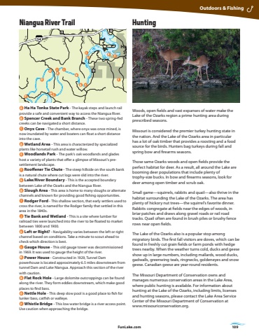
FunLake.com FunLake.com 109HuntingWoods, open fields and vast expanses of water make the Lake of the Ozarks region a prime hunting area during prescribed seasons.Missouri is considered the premier turkey hunting state in the nation. And the Lake of the Ozarks area in particular has a lot of oak timber that provides a roosting and a food source for the birds. Hunters bag turkeys during fall and spring bow and firearms seasons. Those same Ozarks woods and open fields provide the perfect habitat for deer. As a result, all around the Lake are booming deer populations that include plenty of trophy-size bucks. In bow and firearms seasons, look for deer among open timber and scrub oak. Small game%u2014squirrels, rabbits and quail%u2014also thrive in the habitat surrounding the Lake of the Ozarks. The area has plenty of hickory nut trees%u2014the squirrel%u2019s favorite dinner. Rabbits congregate at fields near the edges of woods, in briar patches and draws along gravel roads or rail road tracks. Quail often are found in brush piles or brushy fence rows near open fields. The Lake of the Ozarks also is a popular stop among migratory birds. The first fall visitors are doves, which can be found in freshly cut grain fields or farm ponds with hedge trees nearby. When the weather turns cold, ducks and geese show up in large numbers, including mallards, wood ducks, gadwalls, greenwing teals, ringnecks, goldeneyes and snow geese. Canadian geese are year-round residents.The Missouri Department of Conservation owns and manages numerous conservation areas in the Lake Area, where public hunting is available. For information about hunting at the Lake of the Ozarks, including limits, licenses and hunting seasons, please contact the Lake Area Service Center of the Missouri Department of Conservation at www.missouriconservation.org. Outdoors & Fishing12 346 578910 11 1211314 15161718202123 222425262728 293031323334353637 39404142434445464749 48505152535455565758596061626364656667683819234567891012345678910111213142 13451234 56767891011121314151613424254545WDDDHH HHWWWZZZWWW AAAAWWWDYYYYYYY551351351351351351355525555252525252525252777777775555454544242 KKKKKKYAAAAAEEEBBBBBBAYVVVDDDDAAAAAAJU OWNNNNNNNNOJJJZZF TTTTMM MMMMFFORARAO OP PTTTTTTMMMMMMJJJJTTTTTWWWW134134Osage Beach PkwyOsage Beach PkwyHorseshoe Bend Pkwy CommunityBridgeLR 5-58TT-5TT-15TT-5HLR 5-48LR 5-43Bagnell Dam BlvdO dl Hwy 5Old Hwy 5LR 5-31LR 5-27LR 5-29Old 8 RdLR 5-16Red Hollow RdTT-1LR 5-33Weish RdW-15Hall RdRed Arrow RdBrendal RdWonderland RdGolden Beach RdGrinnett RdSeals Rd Seals RdSeals RdSeals RdHeppard RdIvy Bend RdvI y Bend RdDeerValley RdSpri n g Cove RdLRLR5-355-32LR 5 -36Bass Point RdMilfork LnLake Trail RdCup Tree DrCup Tree DrLittle Proctor RdMini Farm DrPeter Pan DrWebb RdWebb RdCu p TreeDr OzarkHeights RdBlack Elk LnMcCasland RdMcCasland RdDixie R dDeer Ridge DrBig Buffalo RdMoss Ridge DrWhisper i ng Timbers RdCoon Club Rd Artist DrWarren RdCottonwood RdBlackberry Patch Rd5-36DLR5-47L R 5-61LR 5-65LR 5-64EELR 5-72LR 5-77 LR 5-77LR 5- 8 4LR 5-89LR 5 -92LR 5-88LR 5-9154-72LLR 54-80R 54-82AA1LR 54-7C9ountry Club Dr LR 54-81LR 54-85L R 54-88LR 54-8754-90Impala RdIndigo RdShadey RdUpper Prairie RdJ103LR 7-7LR 7-3LR 7-5LR 7-9LR 7-13Granger LnLR 7-6Lowell Williams RdAnderson Hollow RdAnderson Hollow RdMcCubb ni s DrMcCubbins DrMcCubb ni s DrSwinging Bridges RdSwinging Bridges RdSwinging Bridges RdKaiser RdTwin Bays RdTroutdale RdJade RdVillage Mar ina RdLR 54-82Lake of the OzarksState ParkOsage BeachLake OzarkBagnellEldonFour SeasonsSunriseBeachLinnCreekCamdentonMacks CreekLaurieHa Ha TonkaState ParkGravoisMillsVersaillesStoverLake of the OzarksLake of the OzarksLake of the OzarksLake of the OzarksLake of the OzarksGlaize ArmNiangua ArmLittle Ni angua ArmNian gua A mrGravois ArmOsage R vi erA B CDEG FHJ IKL MNOP A Ha Ha Tonka State Park - The kayak steps and launch rail provide a safe and convenient way to access the Niangua River. B Spencer Creek and Bank Branch - These two spring-fed creeks can be navigated a short distance. C Onyx Cave - The chamber, where onyx was once mined, is now inundated by water and boaters can float a short distance into the cave. D Wetland Area - This area is characterized by specialized plants like horsetail rush and water willow. E Woodlands Park - The park%u2019s oak woodlands and glades host a variety of plants that offer a glimpse of Missouri%u2019s presettlement landscape. F Rooffener Tie Chute - The steep hillside on the south bank is a natural chute where cut logs were slid into the river. G Lake/River Boundary - This is the accepted boundary between Lake of the Ozarks and the Niangua River. H Slough Area - This area is home to many sloughs or alternate channels and known for providing good fishing opportunities. I Rodger Ford - This shallow section, that early settlers used to cross the river, is named for the Rodger family that settled in this area in the 1840s. J Tie Bank and Wetland - This is a site where lumber for railroad ties were launched into the river to be floated to market between 1800 and 1900. K Left or Right? - Navigability varies between the left or right channel based on conditions. Take a minute to scout ahead to check which direction is best. L Gauge House - This old gauge tower was decommissioned in 1969. It was used to gauge the height of the river.M Power House - Constructed in 1929, Tunnel Dam powerhouse is located approximately 6.5 miles downstream from tunnel Dam and Lake Niangua. Approach this section of the river with caution. N Flat Rock Hole - Large dolomite outcroppings can be found along the river. They form eddies downstream, which make good places to find bass. O Nettle Hole - This deep slow pool is a good place to fish for lunker bass, catfish or walleye. P Whistle Bridge - This low water bridge is a river access point. Use caution when approaching the bridge.Niangua River Trail
