
Page 36 - Demo
P. 36
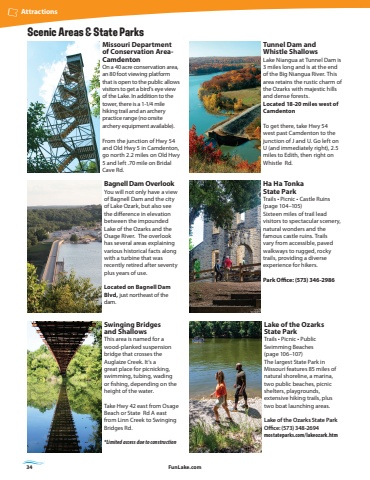
34 FunLake.comAttractionsScenic Areas & State ParksTunnel Dam and Whistle ShallowsLake Niangua at Tunnel Dam is 3 miles long and is at the end of the Big Niangua River. This area retains the rustic charm of the Ozarks with majestic hills and dense forests.Located 18-20 miles west of CamdentonTo get there, take Hwy 54 west past Camdenton to the junction of J and U. Go left on U (and immediately right), 2.5 miles to Edith, then right on Whistle Rd.Ha Ha Tonka State ParkTrails %u2022 Picnic %u2022 Castle Ruins (page 104%u2013105)Sixteen miles of trail lead visitors to spectacular scenery, natural wonders and the famous castle ruins. Trails vary from accessible, paved walkways to rugged, rocky trails, providing a diverse experience for hikers.Park Office: (573) 346-2986Lake of the Ozarks State ParkTrails %u2022 Picnic %u2022 Public Swimming Beaches(page 106%u2013107)The largest State Park in Missouri features 85 miles of natural shoreline, a marina, two public beaches, picnic shelters, playgrounds, extensive hiking trails, plus two boat launching areas. Lake of the Ozarks State Park Office: (573) 348-2694mostateparks.com/lakeozark.htmBagnell Dam OverlookYou will not only have a view of Bagnell Dam and the city of Lake Ozark, but also see the difference in elevation between the impounded Lake of the Ozarks and the Osage River. The overlook has several areas explaining various historical facts along with a turbine that was recently retired after seventy plus years of use. Located on Bagnell Dam Blvd, just northeast of the dam.Missouri Department of Conservation AreaCamdentonOn a 40 acre conservation area, an 80 foot viewing platform that is open to the public allows visitors to get a bird%u2019s eye view of the Lake. In addition to the tower, there is a 1-1/4 mile hiking trail and an archery practice range (no onsite archery equipment available). From the junction of Hwy 54 and Old Hwy 5 in Camdenton, go north 2.2 miles on Old Hwy 5 and left .70 mile on Bridal Cave Rd.Swinging Bridges and ShallowsThis area is named for a wood-planked suspension bridge that crosses the Auglaize Creek. It%u2019s a great place for picnicking, swimming, tubing, wading or fishing, depending on the height of the water.Take Hwy 42 east from Osage Beach or State Rd A east from Linn Creek to Swinging Bridges Rd.*Limited access due to construction
